
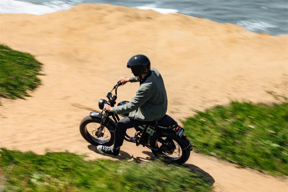
Why Fat Tire E-Bikes Demand Smart Navigation
Fat tire electric bikes excel at tackling diverse terrains that traditional bikes simply can't handle. The oversized rubber adds unmatched stability and traction, letting you tackle everything from snowy trails to sandy beaches, loose gravel, and rugged off-road tracks. This versatility means Tamobyke riders need navigation apps that understand their bike's unique capabilities.
Top Route Planning Apps for 2025
Komoot: The Adventure Explorer's Choice
Komoot is a route planning and navigation app dedicated to outdoor activities, including cycling and hiking, making it perfect for fat tire enthusiasts who love venturing off the beaten path. The app excels at:
- Terrain-specific routing: Automatically adjusts routes based on your e-bike type
- Offline navigation: Download maps for remote trail exploration
- Community insights: Access routes shared by other fat tire e-bike enthusiasts
- Surface analysis: Detailed breakdown of trail conditions ahead
Best for: Tamobyke V29 PRO and T73 Pro Max riders planning multi-day adventures
Strava: The Social Navigator
Strava's ace in the hole is its social component, offering route planning with comprehensive performance tracking. Key features include:
- Heatmap integration: Discover popular routes using crowd-sourced data
- Segment challenges: Compare your Tamobyke's performance against other riders
- Premium route builder: Advanced planning tools for subscription users
- E-bike category: Dedicated tracking for electric bike performance
Best for: Urban commuters using Tamobyke T16 and T63 models who enjoy social cycling
Ride with GPS: The Precision Planner
Our flagship Route Planner empowers riders to create, modify, and share custom routes using a powerful suite of precision mapping, editing, and wayfinding tools. Features include:
- Detailed elevation profiles: Essential for battery management on hills
- Turn-by-turn voice navigation: Hands-free guidance for safer riding
- Device synchronization: Seamless integration with bike computers
- Custom waypoints: Plan stops for charging or sightseeing
Best for: Long-distance touring on any Tamobyke model, especially dual-battery configurations
Tamobyke Model-Specific Terrain Recommendations
Urban Commuting: T16 & T63 Models
- Recommended apps: Google Maps, Strava, Citymapper
- Ideal terrain: Paved bike lanes, urban paths, gentle hills
- Navigation focus: Traffic-aware routing, bike-friendly roads
All-Terrain Adventures: V20 PRO & V29 PRO
- Recommended apps: Komoot, Ride with GPS, TrailForks
- Ideal terrain: Mixed surfaces, moderate off-road trails, coastal paths
- Navigation focus: Surface analysis, weather integration, POI discovery
Extreme Off-Road: T73 Pro Max & T73 Max
- Recommended apps: Komoot, AllTrails, specialized mountain biking apps
- Ideal terrain: Mountain trails, sand dunes, snow-covered paths
- Navigation focus: Gradient analysis, technical trail ratings, emergency features
AI-Powered Navigation Features in 2025
AI-powered systems analyze real-time data from sensors embedded in the bike's frame, monitoring terrain, rider behavior, and environmental conditions. Modern route planning apps now offer:
- Adaptive battery management: Routes adjusted for your Tamobyke's remaining charge
- Weather-responsive planning: Automatic rerouting based on conditions
- Learning algorithms: Personalized suggestions based on riding history
- Safety optimization: Real-time hazard alerts and emergency features
Essential App Features for Fat Tire E-Biking
Battery Range Integration
Choose apps that factor in your Tamobyke's battery capacity and motor power. With the eBike Flow app, you can see how much remaining battery capacity you would have at your destination in the respective riding mode.
Terrain Surface Analysis
The app allows users to create personalized routes based on the type of bike used (mountain bike, road bike, city bike, etc.) and personal preferences. This is crucial for maximizing your fat tire bike's capabilities.
Offline Capabilities
Remote trail riding requires reliable offline navigation. Download detailed maps before heading into areas with poor cell coverage.
Pro Tips for Route Planning Success
- Plan charging stops: Map out locations for mid-ride battery top-ups on longer journeys
- Check trail conditions: Use community features to get real-time trail reports
- Consider weight distribution: Factor in cargo capacity when planning routes with steep climbs
- Weather awareness: Choose apps with integrated forecasting for safer rides
- Emergency preparedness: Select apps with safety features and location sharing
The Future of E-Bike Navigation
Vehicle-to-Everything (V2X) Communication: Some e-bikes communicate with traffic lights and nearby vehicles to enhance safety, reducing accidents at intersections by up to 30% in pilot cities. As smart city infrastructure evolves, expect route planning apps to become even more integrated with urban environments.
Conclusion
The best route planning app for your Tamobyke depends on your riding style and terrain preferences. Urban commuters will love Strava's social features and traffic integration, while adventure seekers should explore Komoot's detailed trail analysis. For precision planning and long-distance touring, Ride with GPS remains unmatched.
Whatever app you choose, remember that fat tire e-bikes like Tamobyke models are designed to go where others can't. Let these smart navigation tools unlock new adventures while keeping you safe and informed on every ride.
Ready to plan your next adventure? Download multiple apps and test them on familiar routes before heading into uncharted territory. Your Tamobyke is capable of incredible journeys – now you have the digital tools to match.

Share:
Rail-to-Trail E-Bike Routes - Best Converted Railways with Tamobyke
Cross-Country E-Bike Routes 2025: Ultimate Long-Distance Touring Guide with Tamobyke